
As of April 2020, these are the political subdivisions in India(28 states, 8 Union Territories).
Prior to independence, India was divided the same way Africa or the Middle East were by colonial powers-arbitrarily, disregarding pre-existing cultural and linguistic disparities in regions.

The newly formed Indian government at the time was quick to realise that if India were to remain one country, states would have to be re-divided on a legitimate basis. Language was made the sole criterion, and it worked. For the first time, all the Bengalis and Punjabis had their own mini nation-states, as did the other regional languages, and soon, the inadvertent sub-nationalism started to gain traction. Citizens could explore their own culture and feel proud about their state in the dominion of India. This played out extremely well for these new states, as rapid economic growth and development ensued in these linguistic states. Karnataka, Gujarat, Maharashtra and Tamil Nadu emerged as economic powerhouses, and friendly competition to attract the most foreign investments or Central funds only played out well for everyone.
The only pitfall of this kind of division is that it only factored on language. In the Northern and Central parts of India, regional languages like Marwari, Bhojpuri and Maithili were declared dialects of Hindi, and so, the Central Government felt there was no need to split these provinces. Even today, Uttar Pradesh, Bihar and other central ‘Hindi’ states are some of the poorest regions in Asia. State parties here played on religion, caste and economic classes to gain a stronger political foothold, and no sub-nationalism emerged, as each region in these states had their own heritage, and so the State could not identify with any of of these cultures to build a strong nationalistic identity.
In 1970’s Assam, the hill tribes, who despised the hegemony of the plain-dwelling Assamese in state politics, were carved out into seven states on the basis of culture, and today, these states have some of the highest literacy rates and Human Development Indexes in the country.
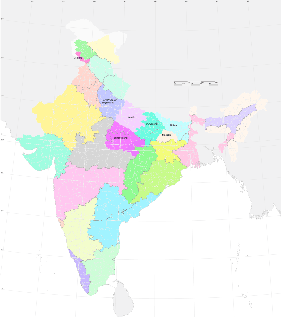
When factoring in dialects and culture, the North-Central India’s map looks very different from current subdivisions. This is because Uttar Pradesh, Bihar and Madhya Pradesh are merely the British colonial states of United Provinces, Behar and Central Provinces with a sloppy facelift.
If any Indian Union Government that comes to power is gutsy enough to break these old barriers and create meaningful provinces, these regions would too go through the process of rediscovering their own culture and traditions, instilling sub-nationalism, resulting in meaningful social and economic development.
About the regions in the above map:
- Bundelkhand
Population: 32 million
Languages: Bundelkhandi, Hindi
Notable historical figure: Jhansi ki Rani
2. Awadh
Population: 79 million
Languages: Awadhi, Urdu, Hindi
Notable Historical facts: Awadh is primarily based on the region ruled by the Nawab of Awadh. The ancient kingdom of Kosala was present in this region
3. Magadh
Population: 24 million
Languages: Magadhi, Hindi
Notable Historical figure: Ashoka the Great, the Mauryan dynasty which ruled most of the subcontinent in the third century BCE.
4. Mithila
Population: 56 million
Languages; Maithili, Hindi
Notable Historical figure/facts: Sita from the Ramayana, Buddha was born in this region. The language Maithili has its own script.
5. Harit Pradesh/ Brij Bhoomi
Population: 67 million
Languages: Braj, Hindi
Notable Historical figures/facts: Birthplace of Krishna, Mangal Pandey started the 1857 revolt here, Mughal capital at Agra.
6. Purvanchal
Population: 66 million
Languages: Bhojpuri, Hindi
Notable Historical figures/facts: Varanasi is the oldest city in India, and is one of the holiest sites for Hinduism; The Bhojpuri film industry is now worth more than ₹2000 crore($300 million).
Notes:
- I have mentioned historical figures and facts for the regions above as it has been noted that these often serve as catalysts for the emergence of nationalism. eg. Maharashtra and Shivaji, Tamil Nadu and Periyar, Punjab and Guru Nanak, Assam and Lachit Borpukan.
- Population figures are from the 2011 census.
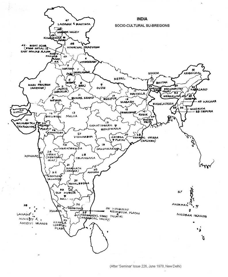
- In this article, I argue for the creation of smaller states in regions where division is incomplete, to promote regional sub-nationalism. Many argue that the rest of India must also be further divided into more manageable units to truly make the most of federalism. In 1973, Rasheeduddin Khan proposed the formation of a 56-state nation, with the primary aim of economic development, as shown in the figure below.

One reply on “An Assessment of Economic Development based on Indian State Maps.”
okay I finally understood what you were talking about this is v interesting
LikeLike